Cadmap Limited Invests in Ground Penetrating Radar to Uncover WWII Bunkers Beneath 1931 Aerodrome
“Advanced PAS128 GPR Technology Uncovers Hidden WWII Air Raid Shelters Beneath Aerodrome, Blending Heritage Discovery with Cutting-Edge Surveying Precision”
Technical achievement and a powerful reminder of the past,” said David, Senior Surveyor at Cadmap Limited. “Using PAS128 standards alongside the Leica DS2000 and Trimble R12i kit''”
LONDON, UK, UNITED KINGDOM, June 24, 2025 /EINPresswire.com/ -- Cadmap Limited, a recognised leader in precision surveying and geospatial services across the UK, announces the significant expansion of its subsurface investigation capabilities with the acquisition of industry‑leading Ground Penetrating Radar (GPR) and precision GPS technology. Utilising PAS128‑compliant survey methodologies, in combination with the advanced Leica DS2000 GPR system and Trimble R12i GPS kit, Cadmap has successfully located previously undetected underground bunkers dating from World War II beneath a Surrey aerodrome—previously used as emergency shelters during periods of aerial bombing.— David Samsmith
🕵️♂️ Bringing History to Light with Cutting‑Edge Geospatial Science
Drawing on their broad experience in subsurface utility engineering, Cadmap’s surveying team deployed a tightly coordinated workflow:
https://www.cadmap.co.uk/surveying/pas128-utility-surveys
PAS128 Survey Planning – A structured approach was adopted in accordance with PAS128:2014 standards to ensure consistency, reliability, and compliance in data collection. A combination of desktop study, geophysical scanning, and targeted ground truthing formed the backbone of the investigation.
Leica DS2000 GPR Imaging – The DS2000 provided high-resolution 3D subsurface imaging over the aerodrome site. Its wide bandwidth and upgraded touchscreen interface enabled operators to detect anomalies with exceptional clarity.
Trimble R12i RTK Positioning – Positional data for all survey points were captured to centimeter precision using the Trimble R12i real‑time kinematic GPS kit, ensuring the underground features detected by GPR were accurately geolocated.
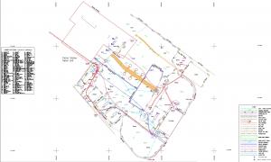
Detailed Post‑Processing – Combining GPR profiles with RTK GPS data, Cadmap produced richly detailed subsurface maps, identifying discrete rectangular voids and reinforced structures consistent with World War II era shelter designs.
The result: a confirmed network of subterranean bunkers, previously unrecorded in historical surveys or local heritage registers, poised to deepen our understanding of wartime civilian protection infrastructure.
https://www.cadmap.co.uk/surveying/pas128-utility-surveys
🧭 A Journey Beneath the Surface: Discovering Hidden Refuge
These reinforced chambers, often buried just 1.5–3 meters below ground level, display key structural elements – thick concrete walls, entrance shafts, and adjoining entry tunnels framed within the aerodrome’s perimeter. The shelters, believed to have offered vital refuge from Luftwaffe bombing raids, vary in length from 8 to 15 metres, and feature arch‑style roofing characteristic of mid‑20th‑century bunker construction.
Cadmap’s Managing Director observed:
“What started as a routine geophysical survey evolved into a journey back in time—revealing uncharted WWII bunkers that encapsulate a powerful narrative of wartime resilience. By blending historical research with today’s geospatial technology, we’ve provided heritage professionals, planners, and local authorities with invaluable insights—all without disturbing the delicate underground legacy.”
🌍 The Broader Impact: Heritage Preservation, Planning & Redevelopment
Cadmap’s findings unlock a spectrum of opportunities:
Heritage Conservation – A rarity in comprehensive wartime infrastructure mapping, this discovery informs future preservation efforts and enhances interpretive programming for local history enthusiasts. https://www.cadmap.co.uk/
Planning & Redevelopment – Developers and planners can now design sympathetically around these subterranean assets—either preserving them in situ, integrating them into adaptive reuse plans, or, where appropriate, back‑filled and monitored.
Community Engagement – Cadmap collaborates with local societies and muted communities to share the stories uncovered and highlight the relevance of these shelters to wartime collective memory.
🔧 Cadmap’s Services: Precision from Topography to Subsurface
Cadmap’s investment not only powers this project but underpins the company’s full suite of specialist services, drawing from decades of geospatial expertise:
PAS128 Subsurface Utility & GPR Surveys
https://www.cadmap.co.uk/
Ideal for identifying buried structures (pipes, cables, voids, bunkers) using geophysics, corroborated with ground‑truth verification and georeferenced in 3D.
Topographical Surveys
Capturing site features to millimetre accuracy using Leica MS50 total stations, drone‑based photogrammetry, and CAD deliverables tailored to architects, engineers, and contractors.
Measured Building Surveys
3D scanning of interior and exterior structures, OCT, and point‑cloud modeling ready for BIM and refurbishment projects.
Utility Mapping & Reconnaissance
Combining PAS128 survey workflows with legacy record collation to assess asset condition, liability, and to reduce risk ahead of excavation.
https://www.cadmap.co.uk/
GPR Forensics & Environmental Surveys
Detecting unseen voids, ground targets, archaeological remains, foundations, and contamination boundaries—applied in conservation, remediation, and archaeological contexts.
Clients across public‑sector, heritage bodies, infrastructure, and private development now benefit from this comprehensive offering, based on rigorous methodologies and world‑class equipment.
🛠 Why PAS128 + Leica DS2000 + Trimble R12i = Superior Results
PAS128 compliance ensures traceability, repeatability, and auditability throughout the survey lifecycle—with structured codes (e.g. B2, C2, D2 accuracy) for clarity in engineering and heritage contexts.
Leica DS2000 GPR stands out for its:
Multi‑band, wide‑aperture antennas
Dual‑frequency depth resolution
Intuitive touchscreen with real‑time reflectivity imaging
Trimble R12i GPS system delivers:
Centimetric accuracy via triple‑frequency GNSS
Seamless IMU tilt compensation
Robust data syncing across survey workflows
https://www.cadmap.co.uk/
This collective approach minimises risk, boosts confidence, and delivers high‑fidelity subsurface intelligence far beyond generic utility surveying.
💬 Voices from the Field
Cadmap Survey Team Lead:
“Running the DS2000 transects over suspected hotspots and watching the RTK‑anchored plots align perfectly—it was surreal. These bunkers lay undetected, unmarked, until today.”
Local Heritage Society Representative:
“We’ve long known civil defence sites existed in Surrey, but Cadmap’s survey adds real substance—now we can add them to the public record and protect them responsibly.”
📣 Get in Touch
Cadmap invites planners, architects, developers, heritage bodies, and local authorities to explore their full range of subsurface and spatial surveying solutions:
PAS128 GPR & sub‑surface utility services
Topographical & measured building surveys
3D scanning & BIM integration
Utility detection & environmental forensics
Contact Cadmap today to collaborate on your next precision mapping or heritage site investigation:
📞 +44 (0)1483 429385
✉️ info@cadmap.co.uk
🌐 www.cadmap.co.uk
🔖 About Cadmap Limited
Cadmap Limited is a Surrey‑based geospatial consultancy specialising in precision surveying, 3D modeling, geophysics, and utility detection for architects, engineers, heritage organisations and developers. Founded in 2007, Cadmap has become a trusted partner in UK project delivery—delivering spatial intelligence with unwavering accuracy and innovation.
Andy Finn
Cadmap Limited
1483429385 ext.
email us here
Visit us on social media:
LinkedIn
Instagram
Facebook
YouTube
X
Work Flow
Legal Disclaimer:
EIN Presswire provides this news content "as is" without warranty of any kind. We do not accept any responsibility or liability for the accuracy, content, images, videos, licenses, completeness, legality, or reliability of the information contained in this article. If you have any complaints or copyright issues related to this article, kindly contact the author above.


